2 August 2013, was our final travel day back to Jackson Hole and eventual (uneventful) flight back to Baltimore. We left Canyon Village early so that we could enjoy our road trip back through the heart of Yellowstone, around Yellowstone Lake, and south to exit the park and back into Grand Tetons National Park (GTNP). The photo above is a testament to yet another beautiful day in the Tetons. One of our side trips back inside GTNP was on a very nice 5 mile road up to Signal Mountain. Here is a picture and video from that area.
Chris posing at the top of Signal Mountain overlooking Jackson Lake and theTetons, GTNP, Wyoming - August 2013
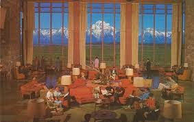
We also stopped at Jackson Lake Lodge and were highly impressed with this property and the location. Here is a photo (not ours) taken from the lobby with this magnificent view of the Tetons. When we make it back to the Tetons we will make it a point to stay at this lodge. We may have to take out a loan, but it would be worth it!
One of many flower boxes outside of the Jackson Lake Lodge
Here are some photos taken near Jackson Lake with the Tetons as a backdrop. Who wouldn't take a photo on a day like this!
Taken from the patio outside the Jackson Lake Lodge
As sad it may seem...and it was...we exited GTNP and headed back into Jackson Hole. We spent one more night there, did some touristy walks around the town, had a nice dinner, and then left Wyoming on 3 August back to Baltimore.
Chris posing in the Jackson Hole town square and elk horn arch
On a final note and reflecting back on this vacation Cindy and I admit that this was one for the memory books. As noted in these various blogs we accomplished a lot in two weeks and would not change a thing (except more Fly Fishing!). Picking the Goosewing Ranch in the Gros Ventre National Forest, which was not on the original itinerary, turned out to be one of many highlights of the trip. The location, staff, horseback trail rides, and overall experience was off the charts! The weather while traveling in GTNP, YNP, and the Beartooth/Chief Joseph Scenic Byways was picture perfect. We did not have one single day that was ruined (the hail storm in the Beartooth was actually cool) by rain. Our planned and unplanned hikes were spectacular and each had their own personalities. The wildlife and geology throughout this area did not disappoint, with the exception of not seeing any Wolves. But we chalk the later up for an excuse to just come back! Because they are there...just elusive. We did see a variety of other animals like Black and Grizzly Bears, Black and White Tail Deer, Elk, Bison, Pronghorns, furry little rodents, Cutthroat Trout and various birds of prey including Hawks, Ravens, and Bald Eagles. Through the conversations with the Park Rangers, displays throughout the many visitor centers, and just seeing each Park in the first person we learned a lot more than you can from a book or the internet. The crowds in some of the more popular areas like Yellowstone Canyon/Falls, Old Faithful Geyser Basin, and Mammoth Hot Springs were anticipated and proved that you must have patience and civility. The key is to always take the path less traveled. It's important to note that hiking 100 yards off the beaten path takes you away from the noisy visitors. We give this trip an A+ and highly recommend to anyone who needs some fresh, clean, mountain air; loves the thought of seeing wild animals in their natural habitat; can enjoy the geology that is unsurpassed in beauty, and just plain relaxation should make the effort to see this part of Wyoming. We hope you enjoyed this blog as much as we did in putting it together! Hmmmm...what's next on our bucket list?
1 August 2013, marks our last full day in Yellowstone. We were sad about leaving the park in less than 24 hours, yet excited about our plan for that day, which took us back north to the Tower-Roosevelt area, specifically Tower Falls, and then up to the Northwest of the park to Mammoth Hot Springs. The first part of the trek took us back over Dunraven Pass at 8,859', past Mount Washburn to our East, and then to our initial destination of Tower Falls. This was a short walk but a nice view of a fairly tall and scenic water fall at 132'.
Tower Falls in Yellowstone National Park, Wyoming
After Tower Falls we traveled in a NW direction along the Blacktail Deer Plateau and an area known for one (yes I called it) one petrified tree after a couple mile detour. I suspect more can be found, but you probably have to hike or find them in a museum. Here is photo of Cindy who just had to have her picture taken with this tree. :)
Moving along we rolled up on a Bear jam and got to see another Grizzly, but the distance (probably 2000 yards away) turned out to be a little shaky with the video and cameras. It's always exciting to see these big animals (that's why we picked Yellowstone) in their natural habitat. Here is a video to help you visualize the Northwest corner of Yellowstone and the beautiful day we had.
Right after this area we found yet another waterfall called Wraith Falls. Here is a video of that area.
Just before we entered into the Mammoth Hot Springs area we rounded a bend and found this four legged creature running up and down the road. He was either lost or on the hunt. Here is Part 1 of the Wildly Coyote:
Here is Part 2:
Just after taking the video of the Coyote we entered into the Mammoth Hot Springs area. This is another well known and visited area in the park. The town of Mammoth is inhabited 365 days out of the year and is the historical site of Camp Sheridan (famous Army General of the time) and later renamed Fort Yellowstone. The US Army established this fort in 1891. They did so because the Interior Department, which founded the very first National Park...you got it...Yellowstone in 1872, did not have the resources to effectively manage a wilderness of this size. So they brought in the army. They established mountain patrols for wildlife protection, and protection of natural resources like Mammoth, Old Faithful Geyser Basin and more. In fact today's US Park Service uniforms are still based from this generation of military uniforms. Next time you visit a National Park remember these photos (not taken by me) to see the resemblance:
Now back to Mammoth! Mammoth Hot Springs is outside the original Yellowstone caldera boundary as seen here in the light color with Mammoth to the extreme northern part of the Park:
Geologist's suggest that the energy that supports the geothermal events in Mammoth are attributed from the same magmatic system that fuels the geothermal areas inside the caldera . The water that feeds this area comes from the Norris Geyser Basin (almost 50 miles due South of Mammoth). The minerals that you will see later in this post is a form of Travertine or Limestone. The coloration is created when the limestone comes in contact with the super heated water (hence the Hot Springs). Algae is also a byproduct, which give it the tints of brown, orange, red, and green. Okay geology lesson is over! :) Before hiking up and around the Hot Springs we encountered this lone female Elk who just happened to be standing right outside the active Credit Union. In fact an employee was standing nearby and told us that if it's not an Elk it could be a Bison. They are instructed to just stand by until the animals leave because it's just as much their park as it is ours!
Elk standing in front of the Credit Union at Mammoth Hot Springs, Yellowstone National Park, Wyoming
Here are some pictures and video in the Mammoth Hot Springs area:
Cindy at Mammoth Hot Springs, Yellowstone National Park, Wyoming - August 2013
Chris at Mammoth Hot Springs, Yellowstone National Park, Wyoming - August 2013
Absolute beautiful day to be in Yellowstone!
Video Part 1 - looking down at Mammoth Hot Springs village and surrounding area
Video Part 2 - Actual Hot Springs
Video Part 3 - More active Hot Springs
Since we had driven through every entrance to the Park besides the North Entrance, called Roosevelt Arch, we decided to drive up to Gardiner, Montana and the Gallatin National Forest/Absaroka Beartooth Wilderness to add this to our list. Here are a few photos.
This is looking from Montana into Wyoming at the Roosevelt Arch - North entrance to Yellowstone National Park.
One of my favorite cloud formations and blue sky's that Cindy photographed near Gardiner, Montana and the Roosevelt Arch entrance to Yellowstone National Park
We headed back south past Mammoth and down towards the Norris Geyser Basin. In route we found a really unusual rock formation called the Sheepeater Cliffs. We hope you catch the drift that geology and wild animals fit perfectly into some of our favorite things! Here are some pictures and a video near by they gives a 360 degree view of this beautiful area.
We finally made it past the Norris Geyser Basin (Did not stop) and back towards Canyon Village. Cindy captured one more very nice picture of the Yellowstone River flowing through the Canyon.
Now after looking through these last few blog posts you see why the Naturalists and Geologists in the late 1800's had to convince our government to set aside this wilderness as our first National Park. We are so glad they did and we HIGHLY recommend that you take time to visit this beautiful park. You will not be disappointed. The next and final blog will be our exit out of Yellowstone, back through the Grand Tetons National Park and then to Jackson Hole for our return back to Maryland.
Hello blog readers! I know it's been a long time since our last post, but life sometimes gets in the way. This episode takes us to the top of Mount Washburn; along the Fire Hole River; and out to West Yellowstone. Our first trek of the day was a short drive from Canyon Village up to Dunraven Pass. We got an early start because we had a long day planned and as always we wanted to get in a hike and a lot of sightseeing while we had light. On our way to the trail head parking area at Dunraven Pass we rounded a corner and was greeted by this young Grizzly conveniently munching on some flowers about 40 yards off the side of the road.
This bear was not very big and since we did not see a Mamma Grizzly we just assumed that this was his/her first year alone. Here is a video:
Our first hike of the day was up Mount Washburn. This was a 1,400' vertical assent in just over three miles. At the top the elevation was 10,243 feet. Other than Mt. Fuji (12,389') in Japan, this was the third highest mountain that we ever climbed too. Cindy has made the summit of Mt. Hood (11,250') in Oregon. Here we are on the way up and at the top of Mt. Washburn.
Chris working his way to the top of Mt. Washburn. The Hayden Valley is over his left shoulder.
Cindy nearing the top of Mt. Washburn
Chris & Cindy at the to of Mt. Washburn in Yellowstone National Park
This was a very nice 6.4 mile hike with great 360 degree views. Videos to follow. On top of Washburn is an active fire tower manned by a Park Service Ranger. This seemed to be a very sophisticated fire tower. Not that I have seen a lot, but the fire towers that I've climbed up in to during my early teens in the Blue Ridge Mountains of North Carolina were basically a small hut on top of stilts. This tower had a lot of technical communications gear, including multiple microwave antennas; a full bed room with refrigerator stove; and many more conveniences including his/hers bathrooms with running water. A lot has changed over the years! Here are three videos that provide a much better view than still pictures. The first one is taken just below the summit. The second one is at the top and the last is a view of the Yellowstone Canyon and Hayden Valley.
After the hike we reversed our route back to Canyon Village and turned west towards the Norris Geyser Basin area. More about Norris in Day 13. The road followed within the greater Yellowstone caldera (see post at Old Faithful and Geyser Basin for details regarding the caldera) with various vistas that were not photographed, with the exception of Virginia Cascade. The cascading waterfall was on the Gibbons River.
Virginia Cascade on the Gibbons River
The road took a SW route from Norris Geyser Basin to Madison. At this intersection the Gibbons (with headwaters near Grebe Lake to the NW) and Firehole Rivers (which flows north with headwaters west of Shoshone Lake and through the Old Faithful Geyser basin) form the extremely scenic Madison River. I know that seems like way too much detail (you really need to look at a map of Yellowstone to appreciate), but I want to give the sense of all three rivers coming together in Madison. Each one of them having their own personalities and yes a Fly Fisherman's dream!
Scenic Madison River in Yellowstone National Park, Wyoming
From Madison we took a side trip South heading towards Old Faithful in order to see the Firehole Falls. Here are a couple pictures. Of course Chris had to get in on the action.
Firehole Falls
Just a little ways up the road from here we encountered a very congested area that was not on the map. As it turned out there a some thermal areas (hence Firehole) and some favorite swimming holes that the Park Service turns a blind eye too. People were walking along the side of the road with inter tubes and swim goggles. We unfortunately were not prepared so we just watched from afar and the moved on.
We presided back to Madison and then turned West and followed the Madison River all the way out to the entrance/exit at West Yellowstone. This area has certainly built up since we were here in 1988. We stopped to look around the tourist shops and had dinner. Yes it was pizza but no it did not register on my world famous pizza list. :(
Unfortunately this road trip was not a loop route so we had to follow the same road back to Canyon Village. Just note that when you are in an area that you are not familiar with, there is bound be something you missed or wildlife that was just not present when you went through the first time. Here is a waterfall that we drove past but did not stop the first time around. This is Gibbon Falls.
Gibbon Falls between Norris Geyser Basin and Madison in YNP.
On the road East between Norris and Canyon Village we were happy to see more Elk. We actually captured these on video.
Here is a single elk cow right beside the road.
This was another great day in the park blessed with perfect weather and very scenic rivers.
Day 13 is planned for Mammoth Hot Springs. So stay tuned as always!
Day 11 brings us to another exciting part of our adventure. We are now transitioning from Wapiti, WY into a three night stay in the Canyon Village area of Yellowstone and probably one of the most photographed waterfalls in the world. But before we get to the area photographed above, we had to hitch up the Subaru and head west out of Wapiti. We had the pleasure of traveling along the Buffalo Bill Cody Scenic Byway. This incredible road, that parallels the North Fork of the Shoshone River (see below), has some of the most amazing geology that we have witnessed. The light from the sunrise was just perfect for some of these photos. To us this is what the western part of America should look like. It was breath taking.
That is an amazing balancing act!
We made our way back into the east entrance of Yellowstone and continued west to Fishing Bridge. As I have mentioned before this area is the headwaters of of the Yellowstone River. In this particular section of the river you would think that this is a lake, but I assure you it is a moving body of water. The photo below was captured by Cindy and I believe another one of her award winning shots. The cloud reflection and angle of light really makes this a beautiful shot.
Here is another photo along the Yellowstone River that has a few interesting things going on. The thermals in the center bottom and on the left are a highlight of this picture and typical along this stretch, but notice the fly fisherman (bottom right and near center) standing in the middle of the river. When I think of fly fishing this has got to be an experience of a lifetime and in the top five locations on their bucket list.
Moving along...we are back into the Hayden Valley, which by most accounts we suspected encounters with Bison, and sure enough they were plentiful. The easiest route for these huge animals is to just walk down the middle of the road. And as I mentioned in earlier posts they could simply careless. This is their natural habitat and if someone wants to build a road in it...so be it...they will and did take advantage of it.
UNBELIEVABLE! This is not a telephoto shot. This big guy walked right next to the car.
Here are a few videos of the same Bison you see above. Cindy and I were really exciting regarding this encounter so we had every type of recording device in use so we would not miss anything!
Here is the big guy on video walking right beside the car!
The above pictures and videos were pretty much a couple of lone bulls just hanging out. The next set is a couple of miles up the road where the bigger herd was located. The next video we have bulls, cows, and calves. Some of the Bulls are were getting a little vocal and sizing up each other. You just need to turn up your audio to hear them.
We believe one of the Bulls across the river from this herd...heard all the commotion and decided to investigate. However, he had to swim across a pretty deep section of the Yellowstone River. We call this our National Geographic Moment of the day!
It was still very early in the day so we did a lot of exploring in the Canyon Village area. The highlight of this area is the Yellowstone Canyon and the upper/lower waterfalls.
Upper Yellowstone Falls
Here are the videos of the Upper Yellowstone Falls to accompany the still shots above. Please note that Cindy mistakenly called this the lower falls, but it is in fact the upper falls. Simple mistake caught during the editing of this blog. :)
We drove a few miles down the road from the Upper Falls into one of the most congested areas of YNP. The Lower Yellowstone Falls (308' drop) is probably one of the most photographed waterfalls in the US if not the world. I know some folks might suggest that Niagara Falls would be the number one. I have my opinion since I have seen both, and bar none this is the most scenic based on the back country feel and the geology that surrounds the canyon below the falls.
We had to wait patiently to get this photo as the hordes of photographers were jockeying for this one position. We would have taken a video, but for narration reasons we did not want to talk over the numerous languages and tour guides.
So instead we did what Cindy and I do best and that is hike away (its very true...you walk 100 yards away from any trail head (congested area) and you lose 95 percent or more of the visitors to get better shots --- hence the picture you see at the beginning of this post. Here is a video.
Here is a shot down the Canyon, which is just as amazing as the waterfall. The colors are where the name Yellowstone were derived from. I know that is obvious to most, but I just thought I would mention it.
Chris very near the Lower Yellowstone Falls, Yellowstone National Park, Wyoming
Resting on vacation is not in our DNA, so after we got settled into our cabin we gathered our packs, hiking poles, water, and bear spray and headed out for 4.5 mile hike out to Cascade Lake.
This was very much in Bison and Grizzly country. Hikers just finishing up their hike warned us that they had seen a Momma Grizzly with her two cubs. At this point Cindy and I were probably the most awake and focused humans in YNP! I believe my head was on a swivel looking around for any sign. Unfortunately we did not see any bears. :(
We heard some thunder and decided to high tail it back to the parking lot. That was probably the fastest egress that we had ever done in a long time. The wind had picked up so fast as we were entering sections of trees like you see behind Cindy in the photo above, that we could hear BIG trees falling down. There is nothing boring about our adventures!
After dinner and the thunder storm we decided to drive back into the Hayden Valley too catch any animal life that tend to move out of the tree line and into the grassy fields at dusk. Again we were not disappointed as these two Bull Elk decided to show up. We believe they were just waiting out the storm as well.
Personal opinion, but these are one of the most majestic animals in the wild kingdom.
That ends Day 11. On Day 12 we made plans to hike up Mt. Washburn and to the Fire Tower. I'll be posting that later on.