 |
| Tower Falls in Yellowstone National Park, Wyoming |
After Tower Falls we traveled in a NW direction along the Blacktail Deer Plateau and an area known for one (yes I called it) one petrified tree after a couple mile detour. I suspect more can be found, but you probably have to hike or find them in a museum. Here is photo of Cindy who just had to have her picture taken with this tree. :)
Moving along we rolled up on a Bear jam and got to see another Grizzly, but the distance (probably 2000 yards away) turned out to be a little shaky with the video and cameras. It's always exciting to see these big animals (that's why we picked Yellowstone) in their natural habitat.
Here is a video to help you visualize the Northwest corner of Yellowstone and the beautiful day we had.
Right after this area we found yet another waterfall called Wraith Falls. Here is a video of that area.
Just before we entered into the Mammoth Hot Springs area we rounded a bend and found this four legged creature running up and down the road. He was either lost or on the hunt.
Here is Part 1 of the Wildly Coyote:
Here is Part 2:
Just after taking the video of the Coyote we entered into the Mammoth Hot Springs area. This is another well known and visited area in the park. The town of Mammoth is inhabited 365 days out of the year and is the historical site of Camp Sheridan (famous Army General of the time) and later renamed Fort Yellowstone. The US Army established this fort in 1891. They did so because the Interior Department, which founded the very first National Park...you got it...Yellowstone in 1872, did not have the resources to effectively manage a wilderness of this size. So they brought in the army. They established mountain patrols for wildlife protection, and protection of natural resources like Mammoth, Old Faithful Geyser Basin and more. In fact today's US Park Service uniforms are still based from this generation of military uniforms. Next time you visit a National Park remember these photos (not taken by me) to see the resemblance:
Mammoth Hot Springs is outside the original Yellowstone caldera boundary as seen here in the light color with Mammoth to the extreme northern part of the Park:
Geologist's suggest that the energy that supports the geothermal events in Mammoth are attributed from the same magmatic system that fuels the geothermal areas inside the caldera . The water that feeds this area comes from the Norris Geyser Basin (almost 50 miles due South of Mammoth). The minerals that you will see later in this post is a form of Travertine or Limestone. The coloration is created when the limestone comes in contact with the super heated water (hence the Hot Springs). Algae is also a byproduct, which give it the tints of brown, orange, red, and green. Okay geology lesson is over! :)
Before hiking up and around the Hot Springs we encountered this lone female Elk who just happened to be standing right outside the active Credit Union. In fact an employee was standing nearby and told us that if it's not an Elk it could be a Bison. They are instructed to just stand by until the animals leave because it's just as much their park as it is ours!
 |
| Elk standing in front of the Credit Union at Mammoth Hot Springs, Yellowstone National Park, Wyoming |
Here are some pictures and video in the Mammoth Hot Springs area:
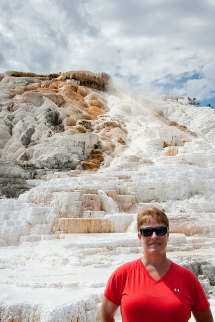
 |
| Cindy at Mammoth Hot Springs, Yellowstone National Park, Wyoming - August 2013 |
 |
| Chris at Mammoth Hot Springs, Yellowstone National Park, Wyoming - August 2013 |
 |
| Absolute beautiful day to be in Yellowstone! |
Video Part 1 - looking down at Mammoth Hot Springs village and surrounding area
Video Part 2 - Actual Hot Springs
Video Part 3 - More active Hot Springs
Since we had driven through every entrance to the Park besides the North Entrance, called Roosevelt Arch, we decided to drive up to Gardiner, Montana and the Gallatin National Forest/Absaroka Beartooth Wilderness to add this to our list. Here are a few photos.
 |
| This is looking from Montana into Wyoming at the Roosevelt Arch - North entrance to Yellowstone National Park. |
 |
| One of my favorite cloud formations and blue sky's that Cindy photographed near Gardiner, Montana and the Roosevelt Arch entrance to Yellowstone National Park |
Here are some pictures and a video near by they gives a 360 degree view of this beautiful area.
We finally made it past the Norris Geyser Basin (Did not stop) and back towards Canyon Village. Cindy captured one more very nice picture of the Yellowstone River flowing through the Canyon.
Now after looking through these last few blog posts you see why the Naturalists and Geologists in the late 1800's had to convince our government to set aside this wilderness as our first National Park. We are so glad they did and we HIGHLY recommend that you take time to visit this beautiful park. You will not be disappointed.
The next and final blog will be our exit out of Yellowstone, back through the Grand Tetons National Park and then to Jackson Hole for our return back to Maryland.


